
Jamaica Strengthens Disaster Response Capacity With New Governance Framework
KINGSTON, Jamaica – Jamaica has strengthened its disaster response and recovery capacity for the 2026 Atlantic Hurricane Season through a Memorandum of Understanding (MOU) establishing GeoConnect, a multi-agency data governance framework.
 GeoConnect provides a single, secure platform that enables ministries and agencies to share, cross reference, and verify damage assessment data in real time.
The MoU was signed by Director General of the Office of Disaster Preparedness and Emergency Management (ODPEM), Commander Alvin Gayle, along with five Permanent Secretaries, during a ceremony earlier this week.
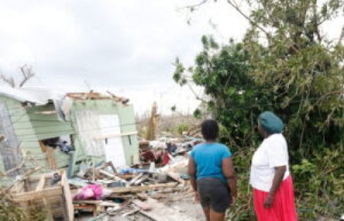
Permanent Secretary in the Ministry of Economic Growth and Infrastructure Development, Arlene Williams, noted that the initiative was conceived in response to the devastating impact of Category Five Hurricane Melissa in October 2025.
It was developed by the National Spatial Data Management Branch, a portfolio agency within the Ministry.
GeoConnect enables participating agencies to match beneficiary records across platforms using taxpayer registration numbers (TRN), location, and assessment data.
The platform flags overlapping submissions, detects duplication of benefits, and supports the transparent allocation of public resources.
“In a recent Auditor General report, she spoke about duplication of benefits, and these are risks that we mitigate by having such a platform in which we can cross-check the data,” Williams highlighted.
She explained that the platform enables officials to review beneficiary records and make informed decisions whenever a previous benefit has been identified.
The Permanent Secretary emphasised that identification of a previous benefit does not automatically disqualify beneficiaries from receiving additional support.
Instead, the type and scale of any additional benefit will be determined by the level of assistance already provided.
“By signing this Memorandum of Understanding, together with the accompanying data sharing and data processing agreements, we are establishing the governance framework that ensures that this platform operates under the full authority of the Data Protection Act, with clear roles, accountability and safeguards,” Williams stated.
She added that this marks the first time that the Government has implemented a multi-agency geospatial data governance arrangement of this kind.
Williams further stated that the initiative positions Jamaica, not only for the 2026 hurricane season but also for future national programmes requiring coordinated verification across government.